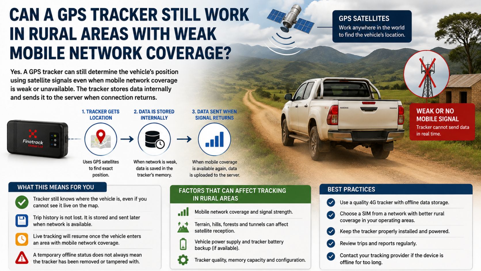
A vehicle leaves Nairobi and travels towards a remote farm, construction site or rural trading centre where mobile phone reception becomes weak. The driver still has the vehicle, the GPS tracker is still installed and powered, yet the location on the tracking platform may suddenly stop updating. For many vehicle owners, that immediately raises the question of whether GPS tracking becomes useless once a vehicle enters an area with poor mobile network coverage.
The answer is more reassuring than many people expect. A GPS tracker can still determine the vehicle’s position even when mobile network coverage is weak, provided it can receive suitable satellite signals. GPS satellites transmit positioning signals independently of the mobile phone network, so the tracker does not require a nearby cellular tower to calculate its basic satellite position.
The confusion comes from the fact that most vehicle trackers use two different communication systems. GNSS or GPS determines where the vehicle is, while the mobile network is commonly used to send that location from the tracker to the remote tracking server. Professional trackers are specifically designed around this combination of GNSS positioning and cellular communication.
This means a tracker can know where the vehicle is while the fleet manager temporarily cannot see that new position on the platform. If mobile coverage disappears, the tracker may continue obtaining coordinates but be unable to send them immediately to the server. The application may therefore continue displaying the last successfully transmitted location until communication improves.
That distinction is especially important in rural Kenya. Mobile broadband coverage has expanded significantly, with the Communications Authority reporting very high 4G population coverage, but population coverage does not mean every kilometre of every rural road has an equally strong signal. Valleys, sparsely populated areas, remote project sites and individual operator coverage can still produce temporary communication gaps.
Consider a company pickup travelling to a remote agricultural project. It may report normally while passing through towns and populated areas, then stop updating after entering a region with weak cellular reception. The vehicle itself can continue travelling normally, and the tracker may still have a valid satellite position even though the newest information has not yet reached the monitoring platform.
A temporary disappearance from live tracking should therefore not automatically be interpreted as tracker failure, tampering or theft. The first thing a fleet manager should check is the last update time and last reported position, then consider whether the vehicle has entered an area known for poor mobile connectivity. Loss of GSM or cellular coverage is specifically identified by professional tracker manufacturers as a reason a device may temporarily stop sending data to its server.
Many professional tracking devices are designed to handle this situation by storing journey records internally. When mobile communication is unavailable, compatible trackers can continue saving records in their memory and then transmit those records after GSM or data connectivity returns. Teltonika documents this behaviour on several tracking devices, including current device families.
For the vehicle owner, this can mean that the journey is not necessarily lost simply because it was not visible live. Once the tracker reaches an area with mobile coverage again, previously stored records may begin uploading to the server and the missing portion of the trip can appear in the journey history. The exact amount of information retained depends on the tracker, memory capacity and configuration.
This creates an important difference between live tracking and historical tracking. Live tracking depends on the device being able to communicate new information to the server at that moment, while historical trip records may still be recovered later when stored data is transmitted. A fleet manager may therefore temporarily lose immediate visibility without necessarily losing the entire record of where the vehicle travelled.
The length of the network outage matters. A short communication gap of several minutes may have little operational effect because the tracker can reconnect and upload its stored information relatively quickly. A vehicle spending many hours or days beyond usable mobile coverage creates a different situation because the device must rely on its local storage until communication returns.
Tracking devices do not have unlimited memory. Some models can store thousands of records when mobile communication is unavailable, but once their storage becomes full, older information may eventually need to be overwritten depending on the device. This is why businesses operating vehicles for long periods in extremely remote environments should discuss expected coverage and device storage with their tracking provider before choosing a system.
The frequency at which the tracker creates records also affects how quickly memory is used. A device configured to record location very frequently will generate more stored data during a long network outage than one operating with longer intervals. Professional tracking systems can therefore be configured according to the operational requirements of the vehicle.
For ordinary rural travel, this often means a well-configured tracker can continue collecting useful trip information until cellular service returns. The fleet manager should nevertheless understand that the vehicle may not be visible second by second during the period without mobile communication. The platform can only show information that the tracker has successfully transmitted.
GPS satellite reception itself can also vary. Rural areas often provide relatively open views of the sky, which can actually be favourable for satellite positioning, but trees, mountains, deep valleys and other physical obstructions can degrade reception. GPS.gov notes that positioning performance depends on factors including satellite geometry, signal blockage and receiver quality.
Weak mobile coverage and weak GPS reception are therefore different problems. A tracker may have excellent satellite reception but poor mobile connectivity, allowing it to know the vehicle’s location while being unable to report it immediately. In another situation, both satellite and cellular signals may be affected because the vehicle is operating in a difficult physical environment.
This distinction matters when troubleshooting. If the tracker begins reporting normally as soon as the vehicle reaches a populated area again, the previous interruption may have been a mobile communication problem. If it remains offline despite returning to a location with good network conditions, management should investigate power, SIM configuration, wiring or device status instead of continuing to blame rural coverage.
The mobile network used by the SIM also matters. One operator may have stronger coverage along a particular route than another, and the tracking provider’s SIM arrangement can therefore influence how reliably the device communicates in different regions. A professional tracking solution needs to consider the vehicle’s normal operating areas rather than assuming one connectivity setup performs identically everywhere.
Businesses working at remote project sites should pay particular attention to this. A construction company may station pickups hundreds of kilometres from Nairobi, while an agricultural business may send vehicles deep into farming regions where mobile coverage can fluctuate. Understanding where live reporting may become intermittent allows managers to set realistic expectations and plan alternative communication procedures.
Transporters should also avoid relying on GPS tracking as their only emergency communication method. A tracker can provide valuable location history and may resume transmitting when coverage returns, but a driver travelling through a known low-connectivity region should still follow the company’s normal communication and safety procedures. Tracking supports operational control; it does not eliminate the need for proper journey management.
This becomes even more important for high-value cargo. A truck transporting expensive goods through remote areas may temporarily disappear from live tracking because cellular communication has been lost. Management should understand the difference between an expected coverage gap and an unusual outage occurring in an area where the tracker normally communicates.
Historical experience can help. If several company vehicles consistently lose communication along the same section of road and return online shortly afterwards, management can identify that location as a predictable network gap. A device that suddenly goes offline on a normally well-covered route deserves a different level of attention.
Geofencing and instant alerts also depend on communication. A tracker may detect or record an event while connectivity is unavailable, but the monitoring platform cannot notify the remote user until the information reaches the server. Businesses should therefore be cautious about assuming every alert will arrive instantly in an area without usable mobile coverage.
This does not make geofencing or alerts useless in rural operations. It simply means that their real-time value depends partly on network availability. Where communication is intermittent, stored records can still provide useful historical evidence after connectivity resumes.
A properly installed tracker also needs reliable vehicle power. Weak mobile coverage does not normally cause the device itself to switch off, but an unrelated electrical problem can produce similar symptoms on the tracking platform. Fleet managers should therefore distinguish between a tracker that is powered but unable to communicate and one that has actually lost power.
This is why professional installation and technical support remain important. A competent tracking provider should be able to review when the tracker last communicated, whether it has regained network access and whether the device is behaving as expected after returning to a stronger coverage area. Guessing from the map alone can lead to incorrect conclusions.
For businesses whose vehicles regularly operate in rural Kenya, tracker selection should reflect that reality from the beginning. The customer should ask whether the device stores records during network outages, how much internal storage it has, which mobile networks the SIM can use and what happens when communication disappears for an extended period. These questions are much more useful than simply asking whether the tracker offers “real-time tracking.”
The same applies to 4G trackers. Modern 4G connectivity can be valuable, but even a 4G device still depends on usable network coverage where the vehicle is travelling. Kenya’s extensive 4G population coverage is encouraging, yet fleet operators should still plan for locations where live connectivity may temporarily be unavailable.
Customers should also remember that the GPS part of the system is global in nature. GPS satellites provide positioning signals independently of Kenyan mobile operators, which is why the tracker can potentially continue determining its position in remote regions even when the cellular network becomes the weaker link.
For private vehicle owners travelling upcountry, the practical message is therefore simple. If the tracking app temporarily stops updating in a rural area, do not immediately assume that the tracker has failed. Check the last location, note the last communication time and see whether normal reporting returns after the vehicle reaches stronger mobile coverage.
For fleet managers, the response should be more structured. Know the areas where your vehicles regularly lose connectivity, investigate outages that occur unexpectedly and confirm that devices upload stored trip data when communication resumes. The larger the fleet, the more important it becomes to distinguish normal network limitations from genuine tracker faults.
Finatrack Global Ltd provides professionally installed GPS tracking and fleet telematics solutions for vehicles operating across Kenya, including businesses whose fleets travel to rural areas and remote project sites. Tracking systems can be configured according to the vehicle’s security and operational requirements, with professional installation and technical support available for customers experiencing tracker communication issues.
Professional installation can be arranged at the customer’s convenient location or at Vision Plaza, 1st Floor, Office 2, Mombasa Road, Nairobi. For GPS tracking and vehicle security solutions, contact Finatrack Global Ltd on 0723 645 810 or visit www.finatrack.co.ke.